Re-Live that Wonderous Flight
 If you fly with a Garmin 76S or any GPS unit that can capture elevation, it is quite easy to view your flight in 3D on Google Earth. Google Earth is free, and is really worth a try. Google Earth uses very detailed satellite photos (you can see individual people in the Seahawks stadium) combined with elevation data obtained using a radar system on board the February 2000 space shuttle mission to create a realistic 3D view of our world.
Google Earth is like a video game in which you fly a helicopter over the earth's real landscape, zooming down into canyons and over mountain tops. Go to your favorite launch and don't be surprised if you see gliders in the air or laid out on launch! The satellite photos are better in some areas than others, and it helps to have a fast internet connection, but I get by with a measley 128 kbps.
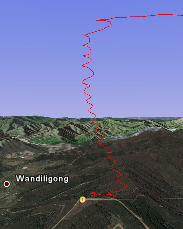
Back to the purpose of this post - which is to overlay your flight on top of the 3D terrain over which you flew. When you set your GPS to record, I suggest you setup the unit to record a point every 2 or 3 seconds, it will make your turns nice and round. When you look at your flight on Google Earth it is as if you left a red line through the sky everywhere you flew, but it gets better - you can look at your corkscrew thermal climbs from any angle - even from slightly below. This is a great learning tool - find out which side of the ridge you found the boomer, or if you fell out the back of the thermal, etc.
To get started, you need a program to download your GPS tracklog, and MaxPunkte is a free one I have used and can be downloaded here. Another nice feature in MaxPunkte is that it will convert your downloaded track (igc file) into a kml file which can then be played in Google Earth. If you already have a program that you use to download your GPS track, but don't want to bother with MaxPunkte, you can upload your track to Leonardo which will automatically convert and store your track so you and your friends can view it in later in Google Earth. By doing that, you also participate in the worldwide Online competition (OLC).
One other tip: You can also analyze the real sky gods flights in Google Earth using Leonardo - just find a flight you are interested in and click on the Google Earth Icon which then shows you things like every thermal they used to go the miles.
Meanwhile, here in Bright, Australia, we are seeing a 3 day cold front leave the area, good flights should be happening soon....
Brett Hardin
posted by Brett Hardin @ 6:50 PM
1 comments
![]()
![]()

1 Comments:
Was that 128 bps or 128 kbps? :)
Post a Comment
<< Home